

08 May Geocaching with Primary Students: Learning by going Off-Map
By Tricia Lonergan
Geocaching is an outdoor recreational activity, in which participants use a global positioning system (GPS) receiver or mobile device and other navigational techniques to hide and seek containers, called “geocaches” or “caches”, anywhere in the world.
A typical cache is a small waterproof container containing a logbook (with a pen or pencil). The cacher enters the date they found it and signs it with their established code name. After signing the log, the cache must be placed back exactly where the person found it. Larger containers such as plastic storage containers or ammunition boxes can also contain items for trading, such as toys or trinkets, usually of more sentimental worth than financial.
Source: https://en.wikipedia.org/wiki/Geocaching
Geocaching has been around since 2000, but you may not have heard of it as it is a secret game. There is a whole host of acronyms used by cachers – TFTC – thanks for the cache, TNLN – took nothing, left nothing. I suspect these have evolved as a shorthand logging technique because of the size of some logbooks within caches.
 I have been a member of this ‘secret game’ for a number of years now and have considered it very appealing to children. The opportunity arose for me to conduct a session for students as part of a Technology Boot Camp incorporating Outdoor education components. Geocaching was the perfect choice.
I worked with a fellow teacher who was keen but uninitiated in caching. Our site was chosen for the particular reason that this school had a class set of mountain bikes we could use for fun geocaching transport.
We had 10 children from 3 different schools attending. Each school was split so we ended up with 2 groups of 15 children.
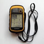
The caching activity began with an introductory lesson on how to use the Garmin eTrex 10 GPS device to locate waypoints already loaded into the devices. Not surprisingly, the students mastered this more quickly than the accompanying teachers. The next step was a short lesson on bicycle safety throughout the school – it was a regular school day so riders needed to be mindful of other students to avoid accidents.
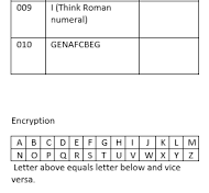 Each pair of students were given a logging sheet to record their finds. This is where it started to look more like an orienteering activity than the traditional geocaching activity as usually the logbook stays with the cache. The logging sheet the students were given had the waypoint number, an encrypted hint and a space to place the sticker from each cache.
Students could use the encryption key to work out the hint if they felt they needed some clues to find the cache.
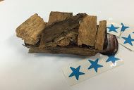
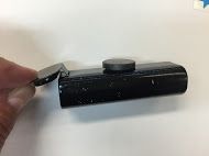 The cache itself was an “Eclipse” mint container which was camouflaged depending upon its location. Caches were painted, rolled in hot glue and sand or bark then magnets were added if needed. Inside each of the caches was a set of individual stickers.
All of the waypoints had been preloaded into the GPS devices. Students set off in pairs on their bicycles armed with their GPS and a log sheet. When they successfully navigated to their waypoint, they searched for the cache, collected one sticker for their log sheet and then set off for the next location. If they had difficulty finding their cache, the encryption code could be used to give a hint.
 10 caches were set up across the entire school – on buildings, in the sand pit, on the tennis court, climbing frame, wheelbarrow in the garden etc. We had an awesome time setting the course up. The students had an even better time finding the caches.
This activity contained a great deal of mathematical content but also addressed several indicators of the Digital Technologies Curriculum:
 Examine the main components of common digital systems and how they may connect together to form networks to transmit data (ACTDIK014)
Acquire, store and validate different types of data, and use a range of software to interpret and visualise data to create information (ACTDIP016)
Design a user interface for a digital system (ACTDIP018) The students explored the features and symbols of the GPS device which provide access to the information irrespective of the language background.
Explain how student solutions and existing information systems are sustainable and meet current and future local community needs(ACTDIP021)
![]() At the conclusion of the day, the students were asked which activity they preferred (throughout the day the students also completed a coding activity using iPads in the air conditioning). Overwhelmingly, geocaching was their preferred activity. The idea of being outside on bicycles using GPS devices to travel across the school and find ‘hidden treasure’ on a very tropical North Queensland day was the hands down favourite. As adults, this is difficult to comprehend but the children embraced it wholeheartedly.
At the conclusion of the day, the students were asked which activity they preferred (throughout the day the students also completed a coding activity using iPads in the air conditioning). Overwhelmingly, geocaching was their preferred activity. The idea of being outside on bicycles using GPS devices to travel across the school and find ‘hidden treasure’ on a very tropical North Queensland day was the hands down favourite. As adults, this is difficult to comprehend but the children embraced it wholeheartedly.
I have wanted to conduct a geocaching activity in a school setting for a while now. I believed it would appeal to the treasure hunter in children. The engagement, teamwork and resilience the students displayed throughout the day made this a must-do activity for my next Technology Boot Camp Day.
My final reflection was what did I get out of it?
I had the joy of introducing the next generation of geocachers to the sport. The time and effort setting this course up was considerable but I would absolutely do it all again. Only two students out of thirty found all of the caches but every single child had a huge smile on their face from the experience. Combining Outdoor Education and Digital Technologies seems to have been a winning formula for student learning and engagement.
Tricia Lonergan
Kylie Docherty
Posted at 20:40h, 11 MayGreat articles. Good work Peter getting the online journal up and running.